


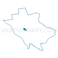
Lawrence township voting district 17, Mercer County, New Jersey
About
Outline

Summary
| Unique Area Identifier | 619607 |
| Name | Lawrence township voting district 17 |
| County | Mercer County |
| State | New Jersey |
| Area (square miles) | 1.03 |
| Land Area (square miles) | 1.03 |
| Water Area (square miles) | 0.00 |
| % of Land Area | 100.00 |
| % of Water Area | 0.00 |
| Latitude of the Internal Point | 40.27943570 |
| Longtitude of the Internal Point | -74.74999030 |
Maps

Graphs
Select a template below for downloading or customizing gragh for Lawrence township voting district 17, Mercer County, New Jersey


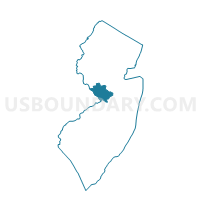
Neighbors
Neighoring Voting District (by Name) Neighboring Voting District on the Map
- Ewing township voting district 15, Mercer County, NJ
- Ewing township voting district 16, Mercer County, NJ
- Ewing township voting district 30, Mercer County, NJ
- Ewing township voting district 31, Mercer County, NJ
- Hopewell township voting district 1, Mercer County, NJ
- Lawrence township voting district 11, Mercer County, NJ
- Lawrence township voting district 13, Mercer County, NJ
- Lawrence township voting district 18, Mercer County, NJ
- Lawrence township voting district 21, Mercer County, NJ
- Lawrence township voting district 3, Mercer County, NJ
- Lawrence township voting district 8, Mercer County, NJ
Top 10 Neighboring County Subdivision (by Population) Neighboring County Subdivision on the Map
- Ewing township, Mercer County, NJ (35,790)
- Lawrence township, Mercer County, NJ (33,472)
- Hopewell township, Mercer County, NJ (17,304)
Top 10 Neighboring Unified School District (by Population) Neighboring Unified School District on the Map
- Ewing Township School District, NJ (35,790)
- Lawrence Township School District, NJ (33,472)
- Hopewell Valley Regional School District, NJ (21,811)
Top 10 Neighboring State Legislative District Lower Chamber (by Population) Neighboring State Legislative District Lower Chamber on the Map
Top 10 Neighboring State Legislative District Upper Chamber (by Population) Neighboring State Legislative District Upper Chamber on the Map
Top 10 Neighboring 111th Congressional District (by Population) Neighboring 111th Congressional District on the Map
Top 10 Neighboring Census Tract (by Population) Neighboring Census Tract on the Map
- Census Tract 33.02, Mercer County, NJ (8,381)
- Census Tract 32.01, Mercer County, NJ (7,932)
- Census Tract 33.01, Mercer County, NJ (7,350)
- Census Tract 35, Mercer County, NJ (7,154)
- Census Tract 37.03, Mercer County, NJ (7,026)
- Census Tract 39.04, Mercer County, NJ (5,904)
- Census Tract 32.02, Mercer County, NJ (5,481)